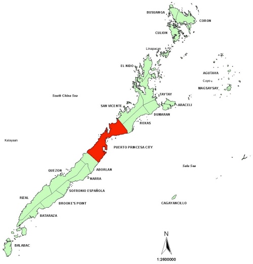
This map came from the Comprehensive Land Use Plan (CLUP) for 2001 to 2010.
At the time that the map was drawn, in 2000 or earlier, three municipalities were omitted: Cuyo, Linapacan, and Kalayaan.
- Why was Cuyo omitted? It’s the oldest town in Palawan. It’s ancient enough to have its own culture and it was Palawan’s capital for 30 years in the late-19th century. Cuyo’s omission was certainly an oversight!
- Between El Nido and Coron (two of northern Palawan’s famous destinations) lies the Linapacan group of islands. Administrative control of the various island barrios was centralized and Linapacan was born. In 1954! Again, I’m surprised it was omitted.
- Kalayaan (which stands for freedom) was created by then-President Marcos in 1976. There was much hoopla around it since the islands are rumored (or confirmed) to lie atop (or around) oil fields. Kalayaan has an interesting history. And once again, I’m surprised it was omitted.
So here’s the map with those three additions!
To magnify this image, click on it and then click on its final resolution.


I was wondering how to get access to the Comprehensive Land Use Plan of Palawan (2001-2010), as I need it for my Case Study presentation. I hope you can help me, thank you! – Ever Tamayo, MS EnvSci, UP Diliman
LikeLike
I’ll email you.
LikeLike
Hi! I am currently doing my thesis about community and site planning and would also like to get a copy of the Comprehensive Land Use Plan of Palawan, specifically of Puerto Princesa City. I’d just like to ask if you can send it to me too? Thank you. – Ariza Aban, BS Architecture, De La Salle – College of Saint Benilde
LikeLike
If so, please email me at arizaaban@ymail.com Thank you so much!
LikeLike