Palawan is one of the least densely populated provinces. Palawan is the second largest province of the Philippines but its 15,000 square kilometers is inhabited by only 890,000 souls (2007). That ranks Palawan 79th, or second to the last, in the population density list of the country’s 80 provinces. So Palawan’s area is second largest and its population density, the second smallest.
I was rather alarmed when I read this in Wikipedia‘s entry for Manila.
Manila has a total population of more than 1,660,000 according to the 2007 census. Manila is the second most populous city in the Philippines behind Quezon City. The populace inhabit an area of only 39 square kilometers, making Manila the most densely populated city in the world.
Metro Manila is the most populous metropolitan area in the Philippines and the 11th in the world with an estimated population of 16,300,000. The greater urban area is the fifth-largest in the world and has an estimated metropolitan population of 20.7 million people.
That was my first reaction. Then I realized that here was further evidence that my decision to relocate to Palawan was correct. Lol. 😉 I am just so looking forward to this. I waited eight long years.
Night Time Earth
NASA, among others, has websites devoted to displaying night time images of our planet.

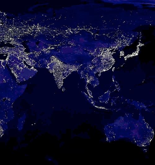
East Asia & Australia (Credit: Geology.com --- http://geology.com/articles/satellite-photo-earth-at-night.shtml)
Zooming in on the Philippines…
Did you notice how all of Palawan–all 425 skinny kilometers of it–is dark except for Puerto?
While contemplating this, here’s more info, courtesy of palawan.com:
- Palawan is made up of 1,800 islands.
- The length of the main island is 425km from tip to tip.
- The distance between extreme north and south of the island province is 650 km.
- The narrowest section of the main island is 8.5 km at Barrio Bahile, at the mouth of Ulugan Bay.
- The widest section is 40 km at Brooke’s Point in the south.
- A chain of tall mountain ranges runs through the entire length of the island, dividing it into two distinct areas called the east coast and the west coast.
Solid bright areas are not necessarily the most densely populated. Think of the central United States against a map of central China. Bright areas indicate the presence of a well-developed infrastructure (e.g., the wonderful interstate highways in the States).
More Night-time Images
Here’s the caption for the next image:
Japan stands out on this satellite view of Asia at night, along with the west coast of Taiwan, South Korea, Hong Kong and Bangkok. The route of the Trans-Siberian Railroad can be seen as a light line across the otherwise dark area of northern Russia. High city densities in eastern China, Indonesia, India and the eastern coast of Australia can clearly be seen. NASA Image.
Do you see the route of the Trans-Siberian Railroad? Doesn’t it look like the track of a giant spider spreading from left to right?
Next is my adopted country where I lived from 1985 to 2010:
And here’s the caption:
This map shows the geographic distribution of night time lights in the United States, Canada, Mexico and the Caribbean. Strong lights occur in a strand that includes Washington, DC, Philadelphia, New Jersey, New York City and Boston. Most of the large cities of Canada are located within a couple hundred miles of the United States border. Chicago stands out on the shoreline of Lake Michigan and other major cities in the central states are collected by a network of highways. On the west coast, Seattle, San Francisco, Los Angeles and San Diego stand out. The coastlines of Florida and Puerto Rico are lined with bright cities. Finally, the cities of Hawaii and oil facilities of the north Alaska coast are also “visible from space”. NASA Image.
And for my European friends.
Its caption:
Western Europe is aglow with night lights. This image clearly shows that the cities of Europe are along the coasts. The Mediterranean coasts of Italy, France and Spain are a solid line of light as is the southern shorelines of the Black and Caspian Seas. The Sahara of northern Africa and the jungles of south-central Africa are largely void of illuminated cities. One of the most striking features on this image is the high concentration of cities on the Nile River, downstream from the Aswan Dam. NASA Image.
How to Enlarge these Images
Click on an image and then click again on the image’s final resolution (encircled).


Inspiring! Our retinas enlarge when we try to see in the dark. At first though, we get scared , because its dim, but as our eyes get used to “the night” we appreciate all the lights around us. Paradox!
LikeLike